
Home Page
|
|
Forecasts of Astronomical Observing Conditions
|
|
|
 |
BACKGROUND:
Pioneering work on forecasting meteorological conditions at astronomical observatories was started in the mid 1990’s. Initiatives by European Southern Observatory (ESO) to forecast conditions at their telescope sites at Paranal and La Silla in Northern Chile have led to the issuing of operational forecasts of surface temperature, cloud cover and precipitable water vapor with an accuracy that is useful for telescope operations. |
|
FORECASTING METHODOLOGY:
The successful prediction scheme employs weather satellite data at 6.7ÎĽm and 10.7ÎĽm in combination with numerical meteorological forecast model data as input to a specially developed program. In the program, algorithms based on the physics of the atmosphere are used to forecast specific cloud cover and water vapor parameters indicative of observing conditions at Paranal and La Silla. Other parameters may also be forecasted utilizing these input data. Data ingest and running of the forecast program is accomplished automatically by means of time controlled scripts. The costs associated with obtaining forecasts for a particular site would include customizing the forecasting methodology to the site, site-specific data acquisition needs and new product development costs. Click here for more details on forecasting methodology.
The entire globe is being monitored continuously by geostationary meteorological satellites. North and South America is in the viewing area of the GOES-8 satellite, the central Pacific is covered by GOES-10 and Africa and Europe by Meteosat-5. The digital data required to produce quantitative forecasts may be purchased from a first order ground receiving station or collected directly using an off-the-shelf receiver. The first option has no initial capital outlay for equipment, provides quality control of the data and requires an annual fee for the data. The second option involves a substantial capital outlay (~US,000), requires the services of someone to monitor the data and maintain equipment, but there is no charge for receiving the data. Numerical meteorological forecast model data are available on a global grid or for selected areas from the European Centre for Medium-Range Weather Forecasting (ECMWF) and the United States National Center for Environmental Prediction. There are costs associated with obtaining these data, again because the agencies preparing the model data charge for their services and/or because someone needs to be paid to obtain and prepare the needed data.
The time required to develop real-time forecasts depends on the location for which forecasts are requested. If the observatory site is within a forecast area where forecasts are already being issued for other observatories, forecast products for the new site could be made available within 6 months. Provision of the forecasts would be dependent on a memorandum of understanding being concluded with existing subscribers within the forecast area. If the observatory is not within an existing forecast area forecast development time would be about 12 months.
Utilities
|
|
NUMERICAL FORECAST MODELS
Close-to-realtime satellite images are excellent, but unless you are a weather expert, they are only good for forecasting the next few hours. Beyond that, the best I've found are numerical weather forecasting models.
The models are big computer programs which create weather maps and even simulated satellite images for times in the future. The satellite-image forecasts are limited to 48 hours.
Some of CMC's numerical forecasts are unique that they are specifically designed for astronomers. While most other numerical forecasts concentrate on predicting rain, wind or tornados, these try to predict clear skies!
Each of CMC's three forecast products predict up to 48 hours into the future, with synthetic images for every three hours.
Observing deep sky objects such as faint galaxies and nebulae requires excellent sky transparency. Astronomers evaluate sky transparency with the faintest star visible to the unaided eye. In semi-desertic regions such as Arizona, one can see stars as faint as 6.5-7.0 magnitude. At mid-latitudes and in the more humid eastern regions, sky transparency is limited to the 4.5-6.0 range in the countryside. Sky transparency also varies with airmass type. With a humid airmass the transparency is reduced significantly. With a continental airmass from the arctic, relatively cold and dry conditions prevail, allowing the sky transparency to be at times be as good as in the semi-desertic regions. Good forecasts of such rare starry evenings will clearly be useful to the amateur astronomer.
|
|
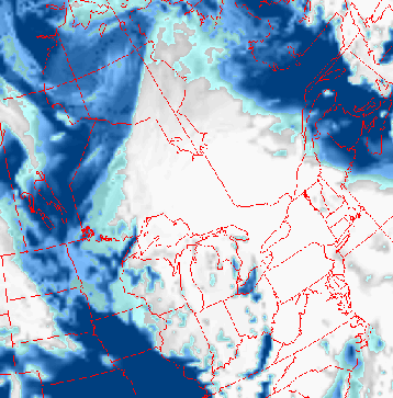
INFARED CLOUDS FORECAST FOR ASTRONOMICAL PURPOSES
1- CIRRUS(thin high clouds).
Numerical weather models do a good job of forecasting cirrus ahead of major weather systems. But, they often overforecast cloud cover. Here we have to distinguish between opacity and cloud cover. The sky could be covered with 9/10 of cirrus but thin enough with only 3/10 of opacity. In other word, despite a nearly full sky coverage, the clouds are so thin that stars are blocked in only 3/10 of the sky. This means that the model cloud cover forecast may look excessive in some cases. Finally we should remember that cirrus isn't very good for deep sky observations but could be helpful for planetary observations.
2- THUNDERSTORMS
Thunderstorms are local phenomena whose dimensions and structures fall below those resolved by weather models. This becomes a problem in warm seasons. Sometimes, they are underforecast and other times overforecast. Thunderstorm development takes large vertical proportions and the cloud tops can be displaced over long distances if they interract with jet streams. Due to the temporal and spatial uncertainty of thunderstorm development in the weather models, the cloud shield can easily end up farther north or south than forecast. So, be careful in using these images in the warm season.
|
|
It is now understood that most future ground based observatories will make use of flexible scheduling tools to select the observing mode best adapted to the observing conditions.
The goal is to inform you about expected sky transparency conditions in your region.
Web utilities
|
 |